View of Mt. Eagle from Ivanhoe
Eaglemont is built on a ridge, giving panoramic views across the Yarra Valley to the Dandenongs.
From the late 1800s into the early 1900s Eaglemont was a favourite picnic spot for Melbournians who would take the train to Heidelberg Station, then trek up Mt Eagle. A Tea House catered for visitors.
A golf course occupied the land above where the Eaglemont Village shops were built from 1925, when the railway station was opened.
There was even a "gentlemens'" cricket ground - of sorts!
Sadly no public open space was reserved out of successive subdivisions. This led to the famed Burley Griffin Estate being designed around private parks. The access to these private parks was limited to those properties where the title bestowed communal ownership. This became a key selling point for these properties.
Public agitation led to Heidelberg Council compulsorily resuming 12 vacant housing allotments in 1922 to form Albert Jones Reserve in Mount Street (formerly known as Main Street).
In 1940 the single housing allotment playground in The Righi was bought by the Council but was equipped by the Eaglemont Progress Association.
In 2023 there is no public open space between Eaglemont Village and Ivanhoe. Banyule Council's standards for public open space indicate there should be three local parks in that area, each capable of providing 15 minutes play for a child.
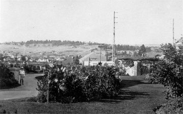
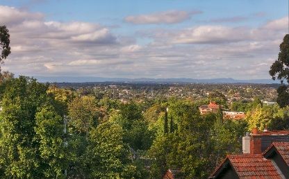
LOOKING TO EAGLEMONT HILL FROM IVANHOE
The top photo is taken from 9 Upper Heidelberg Road Ivanhoe, just east of the bridge over the railway cutting.
#9 was set back from the road with a winding driveway to the street - just beyond the elaborate gazebo and gates in the RH mid-ground.
Only one house is visible on the Mt Eagle ridge line. The
houses in the middle distance are south of Lower Heidelberg Road.
All that open space in the distance was soon to be built out.
Member discussion